
Description
PINDI CHARKAN KHURD
Pindi Charkan Khurd, commonly referred to as Pindi Khurd, is a small rural village located in the Arnia block of Bishnah tehsil, in the Jammu district of Jammu and Kashmir (India). The village falls under the PIN code 181131 and is part of the Pindi Charkan Gram Panchayat.
According to the 2011 Census of India, Pindi Khurd has a population of approximately 338 people, residing in around 75 households. The village is noted for its high literacy rate of over 82%, with education levels significantly above the regional rural average.
The local economy is primarily agriculture-based, with many residents engaged in farming and agricultural labor. Pindi Khurd lies near the India–Pakistan border, within the sensitive Arnia sector, and has occasionally been affected by cross-border tensions.
Despite its small size, the village has access to basic transportation, public services, and holds cultural and strategic significance in the region.
AGRICULTURE
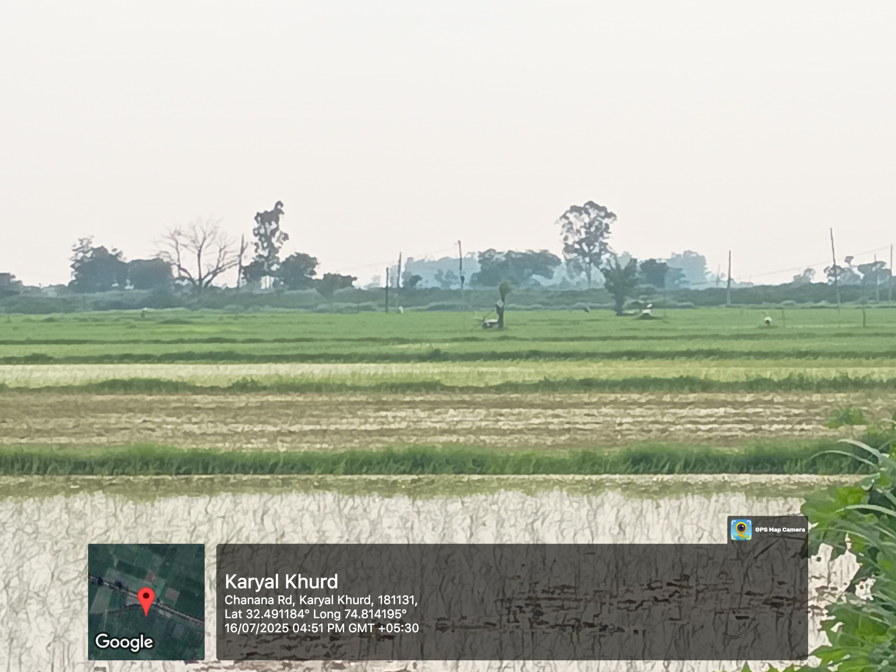
Agriculture is the primary occupation in Pindi Charkan Khurd, forming the backbone of the village’s economy and daily life. According to the 2011 Census:
Out of ~96 working individuals, over 60% are directly involved in agriculture, either as cultivators (10) or agricultural laborers (53).
The land is mainly used for subsistence farming, where farmers grow food crops primarily for their own use and local markets.
🌱 Major Crops
The main crops cultivated in the village and surrounding Arnia region include:
Wheat (rabi season – winter)
Rice (kharif season – monsoon)
Maize (secondary crop)
Mustard and vegetables in small plots for local consumption
💧 Irrigation
Irrigation is done through tube wells, canals, and rain-fed systems, although water availability may vary by season.
Seasonal rainfall plays a significant role in determining crop yield, especially in the kharif season.
🚜 Farming Techniques
Most farming is semi-mechanized or traditional.
Farmers typically use oxen or tractors, depending on affordability and land size.
Use of chemical fertilizers and pesticides is moderate, and there is growing interest in organic and sustainable practices in some areas.
🌾 Challenges
Cross-border tension occasionally disrupts farming during peak seasons.
Small landholdings and limited irrigation infrastructure pose constraints on productivity.
Lack of easy access to modern storage facilities, markets, and agriculture ex
tension services affects profits.
HISTORICAL
1. Origin of Name
The suffix “Khurd” (paired with “Kalan”) is derived from Persian, meaning “small.” It’s used to distinguish a smaller village of the same name from a larger counterpart nearby (e.g. Charkan Khurd vs Charkan Kalan)
+11
Census of India
+11
Village in India
+11
.
2. Arnia’s Legacy and Governance
Arnia town, within whose administrative block Pindi Khurd lies, traces its history to small princely states like Haripur, historically aligned with Sialkot and Jammu during the Mughal era under Aurangzeb's reign. This region later became known as Sohagpur or Sohagpur Arnia. Arnia municipality was formally established in 1962 to manage civic affairs in the growing settlement
Ulb Jammu
.
3. Borderland Vulnerability
Situated just ~5 km from the India–Pakistan border, the Arnia sector—including Pindi Khurd—has endured frequent shelling and ceasefire violations, especially notable during incidents in 2015–2018. Homes, fields, schools, and farms were damaged, causing mass displacement. In 2018 alone, over 76,000 villagers across ~100 hamlets along the frontier fled their homes due to mortar fire
The Financial Express
.
4. Local Impact
While individual historical records of Pindi Khurd are limited, its proximity to conflict areas like Pindi Charkan Kalan and other border villages means that local agriculture, schooling, and daily life have periodically been disrupted. Reports from Arnia sector underscore the trauma experienced by families who lost livestock, endured damaged roofs and fields, and spent nights hiding in makeshift bunkers during intense firing.
BORDER
Pindi Charkan Khurd, often called Pindi Khurd, is situated in the Arnia sector of Jammu district, just a few kilometers from the India–Pakistan International Border (IB). This geographic location places it in one of the most sensitive and frequently tense border zones in the Jammu region.
📍 Geographic Proximity to the Border
Pindi Khurd lies less than 5–6 km from the IB.
Nearby villages like Suhagpur, Trewa, Chak Faquira, and Chandu Chak are all part of this volatile frontier stretch.
🚨 Security Risks and Ceasefire Violations
The village has been historically vulnerable to cross-border shelling, sniper fire, and mortar attacks, especially between 2013 and 2020.
The Arnia and RS Pura sectors have seen multiple civilian and BSF casualties over the years.
During escalations, villagers often evacuate homes and take shelter in community bunkers or safe camps in the interiors.
Example Incidents:
In 2018, over 75,000 people from border villages, including Pindi Khurd, fled their homes during severe mortar shelling (Financial Express, 2018).
In 2015 and 2017, local farmland and schools were damaged in overnight firing incidents (India Today).
🛡️ Border Management Measures
To protect civilian life in villages like Pindi Khurd:
BSF (Border Security Force) maintains multiple forward posts near the fence.
The Indian government built community bunkers, some within or near Pindi Khurd.
Ceasefire agreements signed in 2021 between India and Pakistan have helped significantly reduce firing incidents in recent years, restoring a degree of peace to the region.
🌾 Effect on Daily Life
The border’s volatility directly affects:
Agriculture: Fields near the fence often remain inaccessible during tension.
Education: Schools are closed during shelling; families move children to safer towns.
Livelihoods: Livestock loss, property damage, and emotional trauma have long-term effects.
Infrastructure: Despite improved roads and housing schemes, repeated damage hampers development.
LOCALITY
Location & Administrative Division
Village Name: Pindi Charkan Khurd (also known as Pindi Khurd)
Tehsil/Block: Arnia (previously under Bishnah tehsil)
District: Jammu
Union Territory: Jammu and Kashmir
PIN Code: 181131
Panchayat: Pindi Charkan Gram Panchayat
Police Jurisdiction: Arnia Police Station
Coordinates (approx.): 32.525° N, 74.852° E
🏘️ Surrounding Areas
Pindi Khurd is part of a cluster of villages near the International Border (India–Pakistan). Nearby localities include:
Nearby Village Direction Distance (approx.)
Pindi Charkan Kalan North 1.5 km
Trewa East 2.5 km
Suhagpur West 2 km
Chandu Chak South 3 km
Arnia (town) North-East 5 km
🧑🤝🧑 Population & Community
Population (2011): ~338 people
Households: Around 75
Communities: Primarily Dogra and other Hindu families, with possible Sikh and Muslim minorities in nearby villages
Language: Dogri, Hindi, Punjabi, Urdu (commonly spoken)
🛣️ Infrastructure & Facilities
Feature Details
Road Access Connected by village roads to Arnia and RS Pura
Public Transport Shared autos and buses available from Arnia
Electricity Available under central rural electrification schemes
Water Supply Borewell and handpump-based; no piped water in all homes
Healthcare Nearest PHC in Arnia (~5 km); mobile health camps occasionally
Education Primary School nearby; secondary schools in Arnia
Shops & Markets Local kirana shops; major needs met in Arnia Bazaar
🛂 Strategic Border Proximity
The village lies in the Arnia sector, a known border zone.
The BSF (Border Security Force) is active nearby, with border fencing just a few kilometers away.
Community bunkers exist for civ
ilian safety during times of cross-border tension.
LIVELIHOOD
Village Snapshot (2011 Census)
Population: 338 individuals across 75 households (163 male, 175 female)
www.censusindia.co.in
+9
www.censusindia.co.in
+9
village database
+9
Sex ratio: 1,074 females per 1,000 males (above national average)
Census of India
Literacy: Approximately 82%, with male literacy ~90.8%, female ~74.2%
www.censusindia.co.in
🌾 How People Make a Living
Agriculture & Labor
Out of 338 residents, 96 are reported as workers; 89 in main (=6 month) work, 7 in seasonal or marginal jobs
www.censusindia.co.in
+4
www.censusindia.co.in
+4
Census 2011 India
+4
Most common livelihood is agriculture:
~10 people are cultivators (landowners or co-owners)
53 work as agricultural laborers
Remaining 26 in other roles (local trades, services)
Census 2011 India
+15
www.censusindia.co.in
+15
OneFiveNine
+15
Economic Landscape
The dominant source of income is farming and agricultural labor.
A minor portion of villagers is engaged in other occupations (shops, services, informal intra-village work).
💡 Social & Infrastructure Details
Caste profile: Scheduled Castes represent about 25.4% of the population, with no Scheduled Tribe presence
Census 2011 India
+4
www.censusindia.co.in
+4
Census 2011 India
+4
Connectivity: Public and private bus services exist; nearest railway station is over 10 km away
Village in India
+1
Wikipedia
+1
Nearby Economic Hub: Arjuna town (~5 km away) serves as the local center for markets and services
village database
🧭 Broader Economic Context
Jammu & Kashmir generally has a rural, agriculture-dominated economy. Land ownership is widespread, which provides a degree of financial stability despite limited industrialization and employment opportunities
reddit.com
+1
reddit.com
+1
Development efforts are less in border districts like Jammu, resulting in fewer industries and migration of youth for jobs
reddit.com
+1
reddit.com
+1
✅ Summary: Livelihood Outlook
Attributes Details
Land ownership & farming Key asset and main source of livelihood
Agricultural labor Major employment option for many households
Limited diversification Very few engaged in other trades or sectors
Connectivity Basic transport access, nearby markets in Arjuna
Social structure SC community has significant presenc
e
Challenges Minimal local industry, reliance on farming, seasonal nature of work
Prime Locations
Pindi charkan khurd
See DetailContact Information
| Phone Number |
6005235507 |
| Email Address |